

What is Marine Magnetometry?
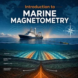
Marine magnetometry is the scientific practice of measuring and analyzing variations in the Earth’s magnetic field beneath oceans, seas, and lakes. This technique is essential for disciplines such as geology, oceanography, archaeology, and environmental science, providing insights into both natural and human-made underwater features.
How Marine Magnetometers Work
Marine magnetometers are sensitive instruments typically towed behind research vessels or mounted on remotely operated vehicles (ROVs) and autonomous underwater vehicles (AUVs). They detect subtle changes in the Earth’s magnetic field caused by underwater geological formations like volcanic rocks and mineral deposits, as well as human-made objects such as shipwrecks, pipelines, or submerged structures.
Applications of Marine Magnetometry
- Geophysical Mapping: Identify the distribution of magnetic minerals in seabed rocks.
- Archaeological Surveys: Locate sunken ships, submerged settlements, and ancient artifacts.
- Resource Exploration: Detect potential sites for oil, gas, and mineral extraction.
- Environmental Studies: Monitor natural and human-induced changes in coastal and marine regions.
- Navigation Safety: Chart potential hazards for maritime operations.
Key Benefits of Marine Magnetometry
Marine magnetometry allows researchers to conduct non-invasive surveys of underwater environments. Its high sensitivity to magnetic and metallic objects makes it invaluable for exploring areas that are otherwise inaccessible or where direct sampling could be impractical or damaging.
Challenges in Marine Magnetometry
- Interference from metallic hulls of ships and onboard electronics.
- Complex overlapping magnetic signals that are difficult to interpret.
- The need for precise navigation to accurately correlate magnetic readings with exact locations.
Future Prospects
Advances in sensor technology and data processing are expanding the potential of marine magnetometry. Its applications in mapping, exploration, and preservation of underwater environments are expected to grow, offering new opportunities for scientific discovery beneath the waves.