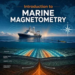


Marine magnetometry is the measurement of Earth’s magnetic field over oceans to study seafloor geology, crustal structure, and magnetic anomalies.

1



Applications of Marine Magnetometry: Mapping and Interpreting the Seafloor
Discover how marine magnetometry maps the seafloor, locates shipwrecks, and aids in resource exploration and environmental monitoring beneath the oceans.

Introduction to Marine Magnetometry: Exploring the Earth’s Magnetic Field Underwater
Explore how marine magnetometry measures Earth’s magnetic field underwater, aiding in mapping, archaeology, resource exploration, and environmental studies.

Marine Magnetometry in Archaeological Exploration: Unveiling Submerged Mysteries
Discover how marine magnetometry uncovers underwater archaeological sites, revealing shipwrecks, structures, and artifacts without disturbing submerged treasures.

The Science Behind Marine Magnetometers: How Subsea Magnetic Measurements Are Made
Explore how marine magnetometers measure subsea magnetic fields, detect anomalies, and reveal seafloor features, supporting research and ocean exploration.
Discover free online courses in Marine Magnetometry designed for students, researchers, geoscience professionals, and anyone interested in learning how magnetic measurements support the study of oceans and the seafloor. These educational courses introduce the scientific principles, instruments, survey methods, and data analysis techniques used to identify magnetic anomalies in marine environments. All courses are free, include exercises to reinforce learning, and offer free certification upon successful completion.
Build valuable knowledge through structured lessons covering geomagnetism, magnetic fields, marine geophysics, magnetometer operation, survey planning, data acquisition, correction procedures, and interpretation. The course content can help learners understand how marine magnetometry contributes to geological mapping, tectonic studies, mineral exploration, archaeology, environmental research, and offshore investigations.
These free Marine Magnetometry courses provide a flexible learning opportunity for beginners and experienced learners. Study from anywhere, review lessons whenever necessary, and complete the educational modules according to your schedule. The included exercises support skill development, while free certification can demonstrate your commitment to continuing education in marine science, oceanography, geology, and geophysical exploration.
The learning materials are suitable for university students, teachers, technicians, survey professionals, ocean science enthusiasts, and independent learners. No matter your educational background, this course collection offers an accessible way to expand your understanding of marine magnetic data and its scientific applications.
To access the courses, exercises, and free certification, you must install the Cursa application. Android users can install it through Google Play at Download for Android. Apple users can install it through the App Store at Download for iOS / iPhone.
Start learning today with free online Marine Magnetometry training and develop relevant educational knowledge in magnetic surveying, marine geoscience, ocean research, geophysical instrumentation, and scientific data interpretation.
What is marine magnetometry?
Marine magnetometry is the measurement of Earth’s magnetic field over oceans to study seafloor geology, crustal structure, and magnetic anomalies.
What will I learn in an Introduction to Marine Magnetometry course?
You will learn magnetic-field fundamentals, survey instruments, data acquisition, anomaly interpretation, and common marine applications.
How is marine magnetic data collected?
Data are commonly collected with a magnetometer towed behind a vessel or mounted on an autonomous underwater vehicle, along planned survey lines.
What is a marine magnetic anomaly?
A marine magnetic anomaly is a local difference from the expected magnetic field, often caused by variations in magnetized rocks beneath the seafloor.
Why is marine magnetometry important for seafloor mapping?
It helps identify geologic boundaries, volcanic features, faults, sedimentary basins, and patterns of oceanic crust formation.
What instruments are used in marine magnetometry?
Common instruments include proton-precession, optically pumped, and Overhauser magnetometers, often supported by GPS and motion sensors.
Can marine magnetometry be used to study plate tectonics?
Yes. Magnetic stripe patterns on the ocean floor provide evidence of seafloor spreading and help reconstruct plate motions and geomagnetic reversals.

Complete any course and issue your certificate via the app — at no cost.
Download the app! to have access to more than 4,000 Online Courses + Certificate, all free!
Download the app! 100% free courses.


Carry knowledge in your pocket.
Download the Cursa app.
There are hundreds of free courses available, with a free certificate of completion that is saved in your mobile image gallery.
Download the app to access the Course Completion Certificate for Free.

+ 10 million
students

Free and Valid
Certificate

60 thousand free
exercises

4.8/5 rating in
app stores

Free courses in
video and ebooks